Dry pattern starting to stress Kentucky corn crop
Dry pattern starting to stress Kentucky corn crop

Many parts of Kentucky have settled into a dry pattern the past 30 days, and it’s starting to stress out some of the corn crop.
“The week before and the week after pollination is the time when corn is most susceptible to the weather,” said Chad Lee, extension grain crops specialist for the University of Kentucky College of Agriculture, Food and Environment. “We really need rain right now in Central and Eastern Kentucky for successful pollination.”
In the past month, the state has averaged 3.36 inches—more than an inch below normal.
“While this does not seem like a lot, Central and Eastern Kentucky counties have shown a more extensive deviation, with both being around 2 inches below normal,” said Matthew Dixon, UKAg meteorologist.
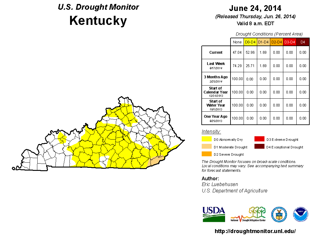
The U.S. Drought Monitor shows nearly 53 percent of the state is now revealing signs of abnormally dry conditions and a small portion of southeastern Kentucky is in moderate hydrologic drought.
Lee explained that the above-average temperatures are compounding the dry conditions.
“It’s definitely not a good combination, but it’s one we seem to face year after year,” he said. “When it gets hot, the crop demands even more water and stress can happen relatively fast. I’ve talked to farmers in this part of the state, and they said the corn looks pretty good in the morning, but it’s looking poor and stressed by the end of the day.”
If current conditions continue, Lee said, the crop won’t be able to recover so easily overnight.
“We have to point out that while signs of drought are beginning to show, it is nowhere close to the drought of 2012,” said Tom Priddy, UKAg meteorologist. “Two years ago at this time, the state was already entrenched in a major drought event. The majority of the state was either showing signs of moderate drought or much worse.”
A major difference between 2012 and this year is that in June of 2012, the state recorded its third driest June on record with a state average of 1.5 inches of rain. This low level of accumulation came after an extremely dry spring season—not the case in 2014.
The U.S. Drought Monitor states ‘abnormally dry conditions’ include the possible impact of a short-term dryness that slows planting or growth of crops or pastures. The latest U.S. Department of Agriculture’s Kentucky Crop and Weather Report confirmed that crops such as corn and soybeans are beginning to show signs of drought stress. Some counties also reported declining pasture quality.
“The upcoming week has isolated- to scattered-chances of rain nearly on a daily basis,” Dixon said. “The latest one-month outlook for July by the Climate Prediction Center has much of the state seeing near-normal rainfall, with the exception of Western Kentucky, where below-normal rainfall is predicted for July.”
Dixon said the near-normal trend extends into September. He also mentioned the return of El Niño.
“We are closely monitoring an El Niño/La Niña climate pattern,” he said. “Above normal sea surface temperatures suggest an El Niño pattern, which is currently anticipated to develop over the latter half of this year.”
During a moderate to strong El Niño phase, Kentucky normally experiences drier than normal conditions in the winter. Dixon emphasized that it’s not something that is affecting the growing season right now.
For current, county-specific and agriculture-impacting weather conditions, forecasts and information, visit the UKAg Weather Center online at http://weather.uky.edu.
Weather
Related News

Smart feeding and planning: Tackling hay challenges for horses amid Kentucky’s drought

By Jordan Strickler
Published on
