From Drenched to Bone Dry, Kentucky is a Tale of Two Climates
From Drenched to Bone Dry, Kentucky is a Tale of Two Climates
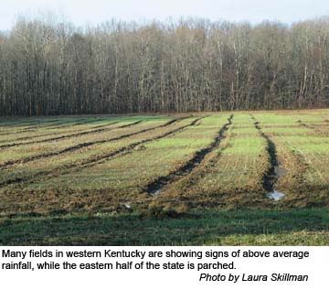

From drenched and muddied fields in the west to parched and dry conditions in the east, Kentuckians are facing climate challenges that will impact summer crops and put forests at risk of fires.
“With all the rain in the western part of the state, it’s hard to believe the eastern half of the state is in moderate drought,” said Tom Priddy, University of Kentucky College of Agriculture meteorologist. “But it’s true; some eastern parts of the state are as many as 6 to 10 inches below normal rainfall.”
Priddy said the predominant storm track throughout the winter months has resulted in much drier than normal conditions across eastern Kentucky, while areas to the north and west have experienced ample to excessive rains. He said the jet stream virtually has split Kentucky into two different weather scenarios.
Autumn rains in western Kentucky made the harvest challenging, and the fields remained very muddy, even into the New Year. UK Soils Specialist Lloyd Murdock said the difficulty may be finding a time when the land will be dry enough to smooth it out and have it back in shape for the coming planting season. 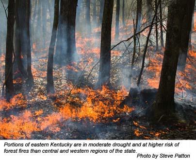 Forest fire season officially began Feb. 15, and despite above-average rainfall amounts throughout Kentucky, UK Extension Forestry Specialist Doug McLaren warned Kentuckians to not let Mother Nature fool them. He said its one of the most vulnerable time for the state’s forests.
The reason for the increased fire potential is simple, McLaren said. Because of the lack of foliage on deciduous trees during this time, solar radiation can quickly dry out the leaves and twigs on the ground. Add to that the high winds associated with low humidity levels, and the debris on the forest floor becomes a fast-burning fuel. Priddy added that recent figures putting eastern parts of the state in moderate drought status just complicates the situation and makes conditions for forest fires even more favorable.
“Due to the dry conditions, the latest edition of the U.S. Drought Monitor issued on Feb. 22 places most areas south of the Mountain Parkway in moderate drought conditions,” he said. “The remainder of the area is classified as experiencing abnormally dry conditions. Rainfall deficits across the area since Nov. 1 range from 1 to 2 inches along and north of Interstate 64 to between 6 and 10 inches south of the Mountain Parkway.”
He added that at the Jackson National Weather Service Office 8.27 inches of precipitation have fallen since Nov 1. This is 6.46 inches below the normal amount for the period. Similar conditions exist at the London Corbin Airport where a 6.51-inch deficit has accumulated since Nov. 1.
“From November through February, eastern Kentucky has seen just over 50 percent of normal rainfall amounts,” Priddy said. “This includes the water equivalent of the recent snowfall. The below- normal precipitation has led to below, to much below normal river and stream flows across eastern Kentucky.”
In contrast, the latest Palmer Drought Severity Index states western Kentucky is in a “very moist spell” and the crop moisture situation is “too wet, some standing water.” The same index reports central Kentucky and the Bluegrass regions are in “unusual moist spells” with “prospects above normal, some fields too wet.”
Looking forward, Priddy forecasts El Niño fading away to near normal conditions in the equatorial Pacific over the next couple months. This will allow the jet stream to return to a more normal position and minimize the split flow to one flow pattern.
“What this means for Kentucky is a return to more normal weather patterns as we move into spring,” he said.