Research Project Teamed UK College of Agriculture, NASA and Private Industry
Research Project Teamed UK College of Agriculture, NASA and Private Industry
A joint project between the University of Kentucky College of Agriculture, NASA and private industry is bringing space age technology into the wheat fields of Kentucky.
All the work is funded by NASA with the Institute for Technology Development-Spectral Visions group being the project implementer. The project is part of Ag20/20's Remote Sensing Product Development Partnership for Agriculture, a collaborative effort between NASA, U.S. Department of Agriculture and commodity groups.
"NASA's goal is to find commercial uses for satellite imagery with our focus being agriculture," said Matt Bethel, research project manager with ITD-Spectral Visions. Bethel's not-for-profit company is the implementer of several agriculture projects under NASA's Ag20/20 program.
NASA's satellite and remote sensing capabilities were used in 2000-2001 in conjunction with UK and Miles Farm Supply in Owensboro to help in determining nutrient needs in wheat.
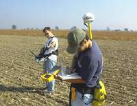
The process uses a sensor that records reflectance data from several wavelengths. The ITD image analysts then utilize this reflectance data to identify crop stresses such as moisture, weeds, and nutrient deficiencies, said Lloyd Murdock, UK Extension agronomist and member of the UK Wheat Science Group.
Sensors being used in the wheat project are similar to those used in satellites, but are installed in a plane to test how they would work if satellites were acquiring the image data, Bethel said.
The Kentucky project was selected because of Murdock's past work with chlorophyll meters and variable rate nitrogen applications.
"We thought that we could use our imagery with his equations applied to the data to make nitrogen recommendations," Bethel said. "The whole point is doing variable rate nitrogen applications based on imagery."
Chlorophyll readings are done using a meter that checks levels in the plant leaves and can be laborious.
"We are going in the fields and taking the chlorophyll measurements while they are acquiring the image data from a plane overhead, and we are correlating the two measurements," Murdock said. "What we want to do is get a good correlation so that we can use the image data alone.
"What you'd do if all works out is fly it and acquire the imagery and then take the computer card out that has the image data and stick it in a computer that already has formulas in it, and say ‘computer tell me how much nitrogen I need for this field,' " he said.
The computer will then provide a map that shows the amounts of nitrogen needed within a field. Next, the computer card with that map is inserted into a variable rate applicator. The applicator contains a global positioning system so it knows where it is in the field and applies the nitrogen rates in accordance with the map.
The theory is to vary the rate as needed, Murdock said. Most farmers do not do that but simply apply a single rate across the entire field.
The project builds on an earlier Idaho project indicating that near infrared images could be used to look at biomass and how it relates to yields, he said. This offers opportunities for farmers and consultants to look at this information in determining possible problem areas in fields before going to scout a field.
"The problems are easy to see," Murdock said. "The image of the field comes back red and you look for the light red or white areas in the field that shows less green vegetative mass. Then, you can go to those areas and look for problems.
"You can pick up areas in the field with the imagery that you might miss by simply walking over it," he said. "If you got these images on a routine basis, it would probably improve your scouting considerably."
All the projects being funded by NASA have to meet certain goals, Bethel said. In the wheat project these goals are to reduce input costs to farmers; to maximize yields and hopefully eventually reduce variability across a field; and to reduce the environmental impact by putting the nitrogen only where it is needed lowering the likelihood of any run-off.
Miles Farm Supply's role in the project is to provide the precision agriculture expertise and equipment, Bethel said.
Carl Dillon, a UK Agricultural Economist, is doing an economic analysis of the data. Bethel said he has found that the farmers who he's worked with on various NASA projects are real forward thinkers and very innovative.
While the project has not been officially approved for another year yet by NASA, Bethel said he expects it will be, and that it will be expanded into other fields in the state.
